


i-Boating: Seychelles, Mauritius & Tanzania - Marine Charts & Nautical Maps app for iPhone and iPad
Developer: Bist LLC
First release : 13 Jun 2016
App size: 45.28 Mb
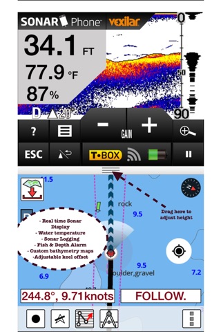
GPS Marine Charts App offers access to charts covering Seychelles Islands, Mauritius and Tanzania. First marine GPS app to have route assistance with Voice Prompts for marine navigation. You can create new boating routes or import existing GPX/KML routes. It supports Nautical Charts course up orientation. Includes Tide & Currents prediction.
►FEATURES
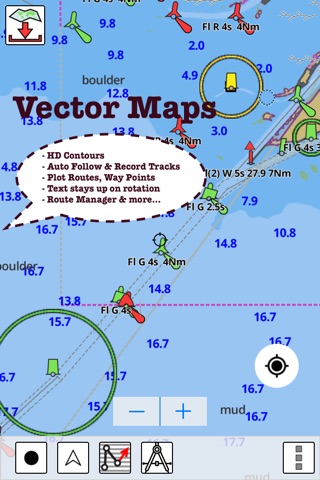
√ Download Beautiful & detailed Hardware/GPU accelerated vector charts (text stays upright on rotation)
√ Query details of Maritime object (Buoy, Lights, Obstruction etc).
√ Custom depth(Ft/Fathom/Meter) & distance units (km/mi/NM)
√ Custom Shallow Depth.
√ Record tracks, Autofollow with real-time track overlay & predicted path vector.
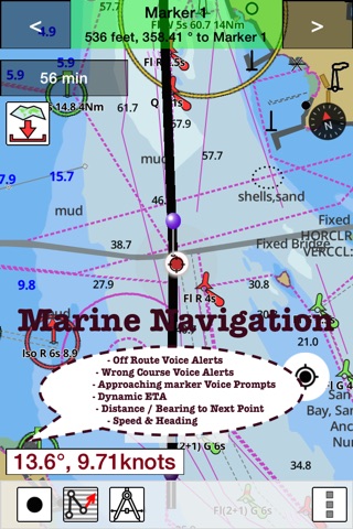
√ Voice Prompts for marine navigation (requires GPS )
√ 1ft / 3ft depth contour maps for anglers for selected lake maps. Useful for fishing/trolling(freshwater/saltwater).
√ Supports GPX/KML for boating route editing/import.
√ Tide & Currents.
√ Seamless chart quilting. Map details from Coastal, Approaches,Harbour, Inland Encs(rivers), and general ENC (Electronic Marine Charts) are automatically mapped to correct zoomlevel
√ Enter / import Waypoints.
► MAPS
Get all the details that you find in your chartplotters!
The maps include coverage of coast of South Africa (derived from SANHO data).
►ROUTE MANAGEMENT / TRIP PLANNING
√ Create New /Edit Routes
√ Reverse Routes
√ Enter,Move, Add, Delete, Rename Waypoints
√ Import GPX, KML & KMZ files
√ Plot/Edit Routes
√ Share/Export Routes, Tracks & Markers
►GPS FEATURES
√ Auto Follow
* Real Time Track Overlay
* Predicted Path Vector
* Course Up (Text stays upright)
* Speed & Heading
√ Route Assistance With Voice Prompts
* Prompts when approaching a boating route marker
* Continous distance & ETA updates
* Alerts when sailing/boating off route
* Alerts when boating in wrong direction
√ Record Tracks
►TIDE & CURRENTS
* For US, Canada, UK,Germany&New Zealand
* High/Low Tides
* Tidal Current Prediction
* Active Current Stations
►CHARTS INCLUDED
√Africa - East Coast - Mafia Island to Pemba Island
√Tanzania - Approaches to Dar Es Salaam
√Tanzania - Approaches to Tanga
√Tanzania - Zanzibar Island - Approaches to Zanzibar
√Tanzania - Tanga
√Tanzania - Dar Es Salaam
√Tanzania - Mtwara to Mafia Island
√Tanzania - North Mafia Channel to Kilwa Main Pass
√Assomption
√Chagos Archipelago to Madagascar
√Cosmoledo Group
√Indian Ocean - Farquhar Group - Entrance to Inner Harbour
√Seychelles Group - Baie Curieuse
√Seychelles Group - Baie Sainte Anne to La Digue
√Seychelles Group - Grand Anse
√F Iles Glorieuses
√Grand Port
√Indian Ocean - Aldabra Island
√Aldabra Island - Ile Picard
√Coetivy
√DArros and Saint Joseph Islands
√Islands North of Madagascar
√Islands North of Madagascar - Farquhar Group
√Les Amirantes - Bancs Africains
√Les Amirantes - Desroches
√Providence Group - Providence and Saint Pierre Islands
√Seychelles Group - Ile aux Vaches
√Seychelles Group - Ile Denis
√Seychelles Group to Agalega Islands
√Seychelles Group to Nazareth Bank and Agalega Islands
√The Seychelles Group
√La Reunion to Mauritius and Ile Tromelin
√Mauritius
√Mtwara to Lamu
√Southern Entrance to Grand Port
► SHARING
* Share tracks/routes/markers on Facebook & Twitter
* Export tracks/routes/markers as compressed GPX files.